


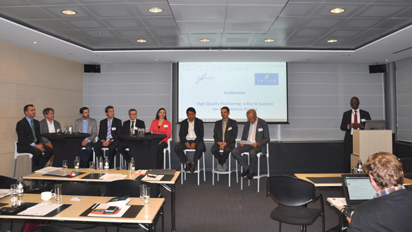
On 4 October, inLane project’s technical coordinator Gorka Vélez (Vicomtech) attended the final event of the European COST Action “Satellite Positioning Performance Assessment for Road Transport” (SaPPART). The conference, entitled “High Quality Positioning: A Key to Success for Autonomous Driving”, was organised by SaPPART and ERTICO (inLane dissemination manager) and held at the BluePoint in Brussels. The event included participants from the automotive industry, map providers, ITS suppliers, telecom industry, road authorities, European institutions, and standardisation bodies.
During the event, Gorka presented inLane’s approach to obtaining an accurate positioning with the fusion of GNSS and computer vision technologies, and he discussed the testing challenges and standardisation possibilities. He also spoke about HD maps, which are vital for the future of autonomous driving. Generating such maps requires the fusion of GNSS with other perception sensors.
However, one of the biggest challenges for the validation and certification of a hybrid system (GNSS + Camera) is that only field tests are available for certification, and “record & replay” testing is not valid for certification, because there is no bench capable of reproducing acceleration and rotation, neither emulating a video data flow with sufficient realism. For this reason, hardware and software interfaces are required, in order to open this black box in a way or another. This will need further efforts from the automotive industry in order to define and agree on these interfaces. In 2017, inLane has started to communicate within the Autodrive Forum about this issue.
inLane has previously cooperated with SaPPART on standardisation issues related to positioning for the inLane Lane Level navigation application. The first step consisted of verifying that the requirements of the current CEN/CENELEC EN 16803-1 [Definitions and system engineering procedures for the establishment and assessment of performances] standard release are applied in inLane.


