


Transport infrastructure is a central feature of any map. It is no surprise the Overture Foundation, with the exclusive help of TomTom, is developing its own data set of the world’s roads – what it calls its transportation layer.
Pascal Clarysse, TomTom VP Engineering Maps, is responsible for various data layers in TomTom’s new map, TomTom Orbis Maps — particularly those related to routing. Due to his expertise in this area, he’s also representing TomTom as part of the Overture Foundation and providing his skills to validate, quality control and process open map data to build the Overture transportation layer.
“One of the goals of Overture is to create the most complete and consistent representation of the world’s road network” Clarysse says. “So, we’re [TomTom] using our expertise to build Overture’s base level map of the world’s road network and ensure that it’s stable, scalable and consistent, and allows us to add more data to it over time to make it as complete as possible.” In practice, doing this takes quite a few steps.
“To make the transportation layer we take open data, which is mostly OpenStreetMap (OSM) at this point, and manipulate it to meet Overture’s requirements,” Clarysse explains.
“We quality check the OSM data to make sure it’s consistent according to Overture’s specification, we segment the road network using a consistent logic for the whole world, and then remap all the relevant road attributes that we know about from the open data to the new map,” he adds.
To ensure the data is complete, TomTom will process and add other open data to the Overture transportation layer in future releases. Combining data from many sources into one transportation layer to create a map dataset that’s stable, rich in detail and highly accurate but, to consumers, “looks and acts as if data is all coming from one source,” Clarysse says.
“A large portion of the work we do is to section the road network, make it consistent across the globe, stabilize it and make it ready for large-scale commercial use,” Clarysse says.
Sectioning or segmenting the road network is important as it creates the foundation for how information (attributes) about the roads is attached to the map — sections can contain information about road surfaces, speed limits, and the number of lanes. Understanding how all these sections link together is what allows location tech companies, like TomTom, to build routing algorithms, detailed maps and other location-based services that help millions of drivers navigate the world’s roads.
The data model for OSM’s transportation layer splits the road based on attribute changes, using a technique called road sectioning.
Road sectioning is great for helping lots of people add lots of detail to a map as it simplifies the map editing process, and it helps with tracking version histories, both of which are great for projects like OSM. But it inhibits stability and scalability as it leads to excess data that changes too dramatically when edits are made.
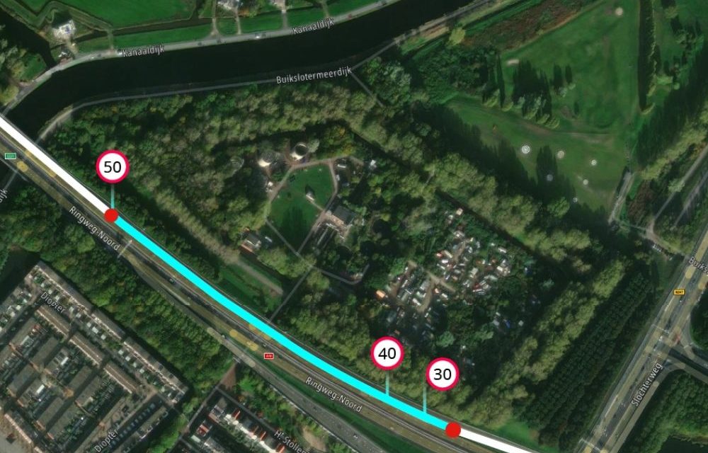
Imagine driving from your home to the highway, you might pass from a 40 km/h limit, to a 50 km/h limit, on a two to four lane road, that’s asphalt and concrete. In road sectioning, each time one of these attributes changes a new section on the map would need to be created with its own unique identifier (ID), in this example there would be four IDs to account for all the different attributes.
However, attributes of a road often change and any time this happens the road’s underlying sectioning is affected, which in turn also affects the ID. If a new speed limit were added to this section of road, it would create a new ID. See in the diagram what happens when a 30 km/h speed limit is introduced — ID #4 is deleted and two new sections (ID #5 and #6) are created to account for the new speed limit.
If another layer of attributes changes, like road surface, the road would require further sectioning and would be made up of many more discrete and unique subsections — in theory, a section of road could be infinitely segmented and have infinite IDs.
Every time a road is split on an attribute change, its original ID gets removed and the new section gets added with a new ID. Changing IDs make maps unreliable and it creates extra work for developers to account for these continual changes. Sectioning road networks like this creates lots of small segments, excess data, which impacts the performance of any product or service built on the map.
Consider a routing algorithm, performance would be poor because it must compute a lot of changes in data between sections to establish the shortest, fastest or most economical route.
However, to create the Overture transportation layer, Clarysse and his TomTom colleagues apply an intelligent segmentation (sectioning) model, called linear referencing. This method does not split roads by attribute changes but instead represents attributes based on their distance along an entire segment of road, greatly reducing the number of IDs and how often they change.
Source:
How TomTom makes the Overture transportation layer | TomTom Newsroom


