


Article by Francesco Ferrero, Head of the Smart City Strategic Program at Istituto Superiore Mario Boella
 As members of the Smart City Strategic Program at Istituto Superiore Mario Boella, we strongly believe in the concept of Scientific Urban Management. This concept means that through new ICT trends such as the massive diffusion of sensors, wireless broadband and tools for data collection and analysis, the administration of urban spaces can get closer to being an exact science, i.e. urban decision-makers can exploit these technologies for practicing evidence based decision making. We are spending quite some efforts in doing research on Decision Support Systems integrating different Modelling & Simulation (M&S) techniques, to better predict and measure the impact of alternative Smart City initiatives on the path towards the social, economic and environmental sustainability target.
We believe that these tools will allow urban decision makers, solution providers and investment managers to predict, on the basis of a scientific approach, what initiatives will better contribute to implement the local Smart City strategies, and to satisfy the real needs of the citizens, thus reducing the risks associated with the deployment of large-scale innovations in the urban context.
Following this research roadmap, we have reached a paramount result on the theme of urban mobility simulation, by means of open-source software and open-data. Our work, done in collaboration with the CNR-IEIIT, University of Bologna and EURECOM has been recently published on IEEE Transactions on Vehicular Technology.
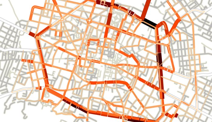
Simulation is an important technique to analyse the complex urban mobility system and to develop tools for supporting decision-making on top of it. However the effectiveness of this approach relies on the truthfulness of the mobility traces used to feed the traffic simulators. Furthermore, there is a lack of reference publicly available mobility traces. The main reasons for this lack are that the tools to generate realistic road traffic are complex to configure and operate, and real-world input data to be fed to such tools is hard to retrieve.
We contributed to the ongoing efforts to develop dependable mobility traces by (i) profoundly changing the behaviour of the SUMO network conversion tool, that is now able to import OpenStreetMap data in a neat, automated fashion, (ii) generating an original dataset of road traffic in the city of Bologna, Italy, and (iii) providing a novel and replicable validation methodology of the simulation results that builds on open-data provided by Google navigation service.
These three contributions are expected to benefit the whole Smart City research community, since they ease the generation and validation of further mobility traces that are instrumental in developing applications in the Smart Mobility sector.


