


Although the recent COVID-19 emergency severely limits the progress of projects all over the business world, Portugal’s “Infraestruturas de Portugal, S.A. (IP, SA), a state-owned company, successfully implemented the TN-ITS solution aiming at collecting Geographical Information System (GIS) features and their integration into a TN-ITS database. The action is carried out under the European CEF project TN-ITS Go that provisions the base layer map data to service providers, like HERE Technologies and TomTom.
Accurate testing is now taking place, collecting feedback from mapmakers and reporting any difficulties in the integration of information received.
“This project is going to enlarge the existing European TN-ITS covered road network with 2600 km, beyond the 100 km already planned high-traffic volumes road network, in the Lisbon district, with the Trans-European Global Network (TEN-T). Infraestruturas de Portugal has access to the roads main attributes (road name, maximum speed, number of lanes and few more), besides their geometry”, announced Mr. Luis Correia and Mr. Fernando Gil, respectively IP department director and project manager.
Infraestruturas de Portugal, S.A. (IP, SA)’s objective is the conception, project, construction, financing, conservation, operation, requalification, enlargement and modernization of the national road and railway networks, including in the latter the command and control of circulation.
“Portugal’s project realisation is also a show case of the vast intention of TN-ITS platform members, to work as a pan-European team and to exchange best practice and experiences. It supports their attempt to implement, maintain and expand the TN-ITS specifications and related standardisation efforts”, says Frank Daems, Sr. Manager at ERTICO and TN-ITS Go coordinator. “This proves that the technology is ready to be implemented beyond the current 14 European Member states”.
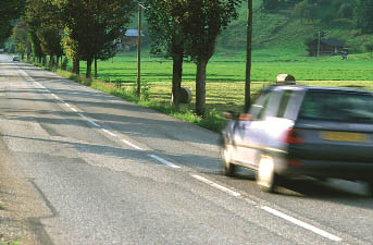
European standardised TN-ITS is a data exchange mechanism for publication ‘base layer data’ such as physical road infrastructure and related attributes like traffic signs, speed limits, in-maps. This data is used by in-car or mobile navigation applications.TN-ITS-enabled map data guides the driver in an accurate way, maintaining the legally imposed road regulations.
These actions enable and support applications such as the European action ‘Go for Zero’, an awareness campaign aimed at reducing the number of road casualties on Flemish and European roads and the planned introduction of ISA (Intelligent speed adaptation).
The TN-ITS platform was set-up in 2013 to facilitate and foster the pan-European harmonized exchange of modifications in road data between road authorities as trusted and quality data providers, and mapmakers and other parties as data users.
TN-ITS services are already active in Flanders, France, Finland, Norway and Sweden, with a total data update rate of more than 1 million per year and is further implemented in eight additional member states.
Road Authorities publish changes of road data as part of their ‘Map Base layer’ Digital Infrastructure data maintenance. Mapmakers retrieve, verify and integrate these changes in their databases and bring this to map users. Drivers can benefit from up-to-date fresh map data that will enable services like ISA (intelligent speed advice/adaptation), or will support driver/traveller information systems on any platform, including mobile devices.
TN-ITS, with its focus on the base layer map data, is compliant, coherent and complementary to other map data-related initiatives aimed at dynamic data information exchange, related to real time information with very short lifetimes.
For more information, visit TN-ITS and TN-ITS Go or contact f.daems@mail.ertico.com .


